In an eUpdate article last month, we examined the counts of 90-degree days across Kansas this summer. At that time, every location had fewer such days than in 2022. Just two weeks ago, it appeared that July 2023 would be one of the cooler Julys on record. Through the first 21 days of July, the statewide average temperature was 76.1°F or 3.0 degrees below normal. Had that been the average temperature for the entire month, it would have ranked in the top 20 coldest Julys on record. Mother Nature turned up the heat starting on July 22 though, and Kansas’ average temperature for the last 10 days of July was 82.8°F. This late-month heat nearly erased the negative departure of the first three weeks of July; the preliminary average temperature for the entire month of July is 78.3°F, or just 0.5°F below normal. In this report, we take a closer look at the means and extremes of this recent heat wave.
Over three-quarters of the Kansas Mesonet sites reached 100°F at least once during the last 10 days of the month. Around one-quarter of the sites reached 100°F on at least half of those days, with Ness City and WaKeeney leading with eight days. On three of the ten days, the average high temperature across all stations in the Kansas Mesonet was over 100°F (Table 1), with the 25th (100.4°F) narrowly edging out the 26th (100.3°F) and 28th (100.2°F) for the warmest average. The highest reading on all three days was the Gypsum site in Saline County at 107.9°F on the 26th.
Morning lows were also unseasonably warm. July 26 had the warmest average minimum temperature at 73.3°F. Five stations had lows in the 80s that morning, with Overbrook in Osage County the warmest at 81.5°F. At a few Mesonet sites, the extreme heat set all-time station records for both warmest high and low temperatures. Four Kansas Mesonet sites in service for 5 or more years recorded new all-time record highs (Table 2), two each on the 26th and 28th. On July 26, seven locations set new all-time record warm minimums (Table 3). Both the Gypsum and Overbrook extremes mentioned earlier were new records. For those locations not setting all-time station records, it had been a few years since temperatures were this hot. At ten Mesonet locations, the highest temperature reached during the last 10 days of July was the hottest reading in over 5 years, and for four of the ten, their highest was the hottest in over 10 years (Table 4).
Table 1. Warmest average high temperatures across the Kansas Mesonet during July 2023.
|
Date |
Average high temperature (°F) |
Number of sites with highs ≥ 100°F |
Highest temp. (°F) |
Location/County |
|
July 25 |
100.4 |
48 |
107.3 |
WaKeeney/Trego |
|
July 26 |
100.3 |
39 |
107.9 |
Gypsum/Saline |
|
July 28 |
100.2 |
38 |
107.6 |
Clay/Clay |
Table 2. Kansas Mesonet sites setting all-time station records for high temperature during the last ten days of July 2023. Only stations in service for more than 5 years are listed.
|
Location |
County |
Highest temp. (°F) / date recorded |
Length of record (years) |
|
Ashland Bottoms |
Riley |
106.9 / July 28 |
9.7 |
|
Gypsum |
Saline |
107.9 / July 26 |
8.4 |
|
Overbrook |
Osage |
104.7 / July 28 |
6.3 |
|
Elmdale 1SE |
Chase |
102.5 / July 26 |
5.1 |
Table 3. Kansas Mesonet sites that set all-time station records for the warmest minimum temperature on July 26, 2023. Only stations in service for more than 5 years are listed.
|
Location |
County |
July 26, 2023 low temperature (°F) |
Length of record (years) |
|
Miami |
Miami |
80.5 |
14.4 |
|
Jewell |
Jewell |
79.3 |
12.5 |
|
Rock Springs |
Dickinson |
78.7 |
9.6 |
|
Olathe |
Johnson |
80.3 |
9.3 |
|
Gypsum |
Saline |
80.8 |
8.4 |
|
Oskaloosa 1SE |
Jefferson |
79.9 |
7.7 |
|
Overbrook |
Osage |
81.5 |
6.3 |
Table 4. Kansas Mesonet sites where the hottest reading during the last 10 days of July 2023 was the warmest temperature in over five years.
|
Location |
County |
Highest temp. (°F) / date recorded |
Last time this temperature was exceeded |
|
Scandia |
Republic |
105.5 / July 28 |
June 27, 2012 |
|
Clay |
Clay |
107.6 / July 28 |
July 25, 2012 |
|
Washington |
Washington |
104.9 / July 28 |
July 25, 2012 |
|
Osborne |
Osborne |
107.1 / July 28 |
July 13, 2013 |
|
Rock Springs |
Dickinson |
106.4 / July 26 |
July 28, 2015 |
|
Jewell |
Jewell |
107.2 / July 28 |
July 21, 2017 |
|
Mitchell |
Mitchell |
107.0 / July 28 |
July 21, 2017 |
|
Ottawa 2SE |
Ottawa |
102.3 / July 28 |
July 22, 2017 |
|
Rossville 2SE |
Shawnee |
99.8 / July 26 |
July 22, 2017 |
|
Manhattan |
Riley |
104.9 / July 28 |
June 28, 2018 |
There were even higher temperatures recorded at cooperative sites. Minneapolis, in Ottawa County, reached 111°F on July 28, Kansas’ highest reading so far this year. Wilson Lake in Russell County and Courtland in Republic County both hit 110°F. There were multiple sites that reached 109°, including at both the Concordia and Manhattan Airports. This was the hottest reading in Concordia in 17 years; it last reached 109°F on July 19, 2006. Had it been just one degree warmer, it would have been the first 110°F in Concordia since 1954. Minneapolis’ 111°F is a few degrees shy of their July record high of 117°F set on July 24, 1936, but it was their warmest July reading since 2011. Lawrence had the warmest minimum temperature in the state on July 26 at 84°, closely followed by Concordia at 83° and a few 82° readings, including at both Topeka and Olathe-Johnson County Executive Airports. Lawrence’s 84° was their warmest daily minimum since September 4, 1947, while Concordia’s 83° was the warmest since July 19, 1954. At both locations, the all-time warmest daily minimum is 86°, set in 1933 at Lawrence and 1936 in Concordia.
Stress Degree Days
The very high temperatures led to stress on Kansas’ corn crop. The amount of stress can be quantified by calculating corn stress degree days. When a daily maximum temperature exceeds 86°F, one corn stress degree day is earned for each degree the high is above 86°F (e.g., Mitchell’s high of 107° on July 28th resulted in 21 corn stress degree days). When 140 or more corn stress degree days are recorded in a growing season, there is a potential for yield loss. Nine Kansas Mesonet sites accumulated 140 or more corn stress degree days in the last 10 days of July (Table 5). When added to the corn stress degree days accumulated prior to July 22, growing season totals are running well above normal in all of these locations.
Evapotranspiration (ET) for the last 10 days of July was also higher than normal (Table 6). Areas in the southwest were closer to normal than in northern Kansas.
Table 5. The highest number of accumulated corn stress degree days during July 22-31, 2023 across the Kansas Mesonet, along with these stations’ totals for the growing season and departures from 30-year normal counts.
|
Location |
County |
Corn Stress Degree Days |
||
|
July 22-31, 2023 |
Growing season |
Growing season Departure from normal |
||
|
Ness City |
Ness |
165 |
416 |
+115 |
|
Gypsum |
Saline |
164 |
427 |
+149 |
|
WaKeeney |
Trego |
162 |
305 |
+32 |
|
Hays |
Ellis |
158 |
337 |
+72 |
|
La Crosse |
Rush |
152 |
347 |
+93 |
|
Osborne |
Osborne |
149 |
318 |
+98 |
|
Gove 5SE |
Gove |
143 |
283 |
+143 |
|
McPherson 1S |
McPherson |
141 |
343 |
+64 |
|
Hodgeman |
Hodgeman |
140 |
406 |
+105 |
Table 6. Total evapotranspiration (ET) at select Kansas Mesonet sites for the period July 22-31, 2023, and 10-year normals for the same 10-day period, based on 2013-2022 data.
|
Location |
County |
July 22-31, 2023 ET (inches) |
Normal July 22-31 ET (inches) |
|
Manhattan |
Riley |
2.21 |
1.98 |
|
Miami |
Miami |
2.10 |
1.73 |
|
Parsons |
Labette |
2.24 |
1.93 |
|
Hutchinson 10 SW |
Reno |
2.65 |
2.21 |
|
Scandia |
Republic |
2.13 |
1.89 |
|
Hays |
Ellis |
2.83 |
2.35 |
|
Colby |
Thomas |
2.58 |
2.28 |
|
Tribune |
Greeley |
2.38 |
2.27 |
|
Garden City |
Finney |
2.37 |
2.29 |
|
Meade |
Meade |
2.26 |
2.21 |
Weather outlook for August 6-10
The heat of late July has lingered into early August, but a cooling trend looks to be on the way. The Climate Prediction Center’s 6 to 10-day outlook, valid for the period August 6-10 (Figure 1), calls for an increased likelihood of below-normal temperatures statewide. In addition, there are elevated chances for above-normal precipitation during the same period (Figure 2). This is good news for those areas of the state where precipitation has been lacking this growing season.
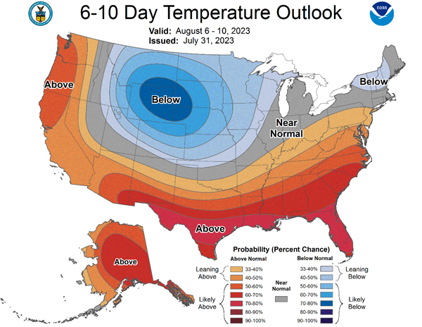
Figure 1. The Climate Prediction Center’s 6 to 10-day temperature outlook for the period August 6-10, 2023.
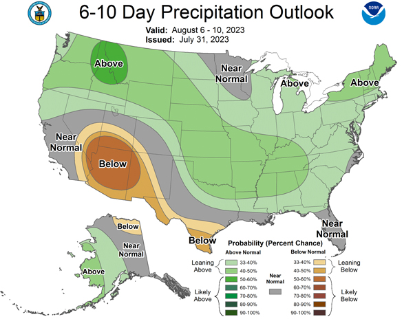
Figure 2. The Climate Prediction Center’s 6 to 10-day precipitation outlook for the period August 6-10, 2023.
Matthew Sittel, Assistant State Climatologist
msittel@ksu.edu
Tags: weather Climate hot weather degree days