Meteorological fall began on September 1. The month began with cool mornings, as the average daily low temperature across the Kansas Mesonet ranged from 52° to 59° from the 1st through the 8th, collectively averaging around five degrees below normal. No site has been in the 30s this fall, but the Hiawatha site in Brown County recorded a chilly 42° on the morning of the 8th, the coldest reading so far this fall.
Daytime highs averaged within a few degrees of normal early in the month but began to consistently average above normal starting on the 8th. As of Sept. 18, we have strung together 11 straight days with above-normal highs across the state. The average high across the Kansas Mesonet was at least 90 degrees on five of those days. Summer-like highs well into the 90s have been recorded at many locations, particularly in the western half of Kansas, with even a couple of triple-digit readings. The co-operative observers in Atwood (Rawlins County) and at Webster Dam (Rooks County) recorded 101° highs on September 9, and the co-operative observer in Healy reported a high of 100° on September 15.
While not unprecedented, the very warm days as of late are atypical of what one expects in mid-September. The normal highs across the state on September 19 range from 77° at Bonner Springs and Olathe to 85° in Sublette. Morning lows for this same date range from 46° in Brewster to 59° in Wichita. Morning lows have been averaging in the 60s for the past week, so it hardly seems the time to discuss the potential for frost and freezing conditions. But climatologically speaking, those two events typically occur in just a few weeks from now. The autumnal equinox, which marks the beginning of astronomical fall, begins this Sunday, September 22. The word equinox is derived from the Latin for “equal night”. Days and nights are roughly the same length on this date, and nights will grow longer with each passing day until December. Less daytime and more nighttime ultimately means cooler temperatures. We will eventually experience a first frost and, in time, a first freeze, which may put an end to the growing season, depending on how far below freezing the temperature gets and how many hours sub-freezing conditions persist. When do the first frost and freeze typically occur in Kansas? Let’s take a closer look at the average dates for these two significant cold weather events.
Data for 20 sites in Kansas were examined using the full period of record at each location. For the purposes of this study, the first frost date is defined as the first occurrence of a temperature at or below 36°, and the first freeze is defined as the first occurrence of 32° or colder. The dates that the first frost occurred each year were sorted from earliest to latest, and then the dates on which 10%, 20%, 30%, etc., of the first frost occurred on or before were identified at each location. This methodology was repeated for the first freeze data.
When we examine the first frost data (Table 1), we see that the median date is in October, except for the far west and northwest areas of Kansas, which occurs in late September. The median date is when there is a 50% chance of the first frost having already occurred. The earliest median date is in Oberlin (September 26), and the latest is in Wichita (October 18). Except for Wichita, there is a 10% probability of the first frost occurring before the first of October at all locations and a 90% probability that the first frost has occurred by the end of October. Last year, Goodland’s first frost was on October 6th, when the low was 31°. This was eight days later than the median date for the first frost, but since it was below freezing, it was also two days earlier than the average first freeze (Table 2). Wichita’s first frost was the next day, on the 7th, but it was over three weeks until their first freeze on October 29. In their case, an early frost was followed by a nearly average freeze date, so an early frost doesn’t guarantee that an early freeze will follow.
Table 1. Probabilities of first fall frost occurring before the given dates based on the full period of record available for each site. Data source: SC-ACIS.
|
First Frost |
10% |
20% |
30% |
40% |
50% |
60% |
70% |
80% |
90% |
|
Chanute |
29-Sep |
3-Oct |
6-Oct |
9-Oct |
12-Oct |
15-Oct |
20-Oct |
25-Oct |
29-Oct |
|
Concordia |
21-Sep |
28-Sep |
1-Oct |
5-Oct |
8-Oct |
11-Oct |
13-Oct |
18-Oct |
24-Oct |
|
Dodge City |
25-Sep |
29-Sep |
5-Oct |
8-Oct |
10-Oct |
11-Oct |
15-Oct |
19-Oct |
23-Oct |
|
Emporia |
28-Sep |
1-Oct |
6-Oct |
8-Oct |
10-Oct |
13-Oct |
16-Oct |
19-Oct |
25-Oct |
|
Fort Scott |
27-Sep |
1-Oct |
6-Oct |
9-Oct |
12-Oct |
17-Oct |
20-Oct |
25-Oct |
30-Oct |
|
Garden City |
20-Sep |
25-Sep |
27-Sep |
30-Sep |
5-Oct |
8-Oct |
10-Oct |
13-Oct |
18-Oct |
|
Goodland |
13-Sep |
17-Sep |
21-Sep |
26-Sep |
28-Sep |
30-Sep |
4-Oct |
6-Oct |
9-Oct |
|
Hill City |
16-Sep |
20-Sep |
23-Sep |
27-Sep |
29-Sep |
5-Oct |
7-Oct |
10-Oct |
15-Oct |
|
Horton |
21-Sep |
25-Sep |
28-Sep |
30-Sep |
6-Oct |
8-Oct |
10-Oct |
16-Oct |
20-Oct |
|
Manhattan |
21-Sep |
25-Sep |
29-Sep |
1-Oct |
5-Oct |
8-Oct |
10-Oct |
12-Oct |
17-Oct |
|
Marysville |
18-Sep |
22-Sep |
27-Sep |
29-Sep |
2-Oct |
4-Oct |
7-Oct |
10-Oct |
14-Oct |
|
Oberlin |
15-Sep |
19-Sep |
20-Sep |
22-Sep |
26-Sep |
27-Sep |
30-Sep |
5-Oct |
9-Oct |
|
Olathe |
26-Sep |
1-Oct |
5-Oct |
8-Oct |
10-Oct |
13-Oct |
17-Oct |
20-Oct |
26-Oct |
|
Pratt |
21-Sep |
28-Sep |
4-Oct |
7-Oct |
10-Oct |
13-Oct |
19-Oct |
23-Oct |
26-Oct |
|
Russell |
22-Sep |
26-Sep |
1-Oct |
3-Oct |
6-Oct |
10-Oct |
11-Oct |
15-Oct |
21-Oct |
|
Salina |
24-Sep |
30-Sep |
4-Oct |
6-Oct |
10-Oct |
12-Oct |
15-Oct |
19-Oct |
25-Oct |
|
Sedan |
27-Sep |
30-Sep |
5-Oct |
8-Oct |
12-Oct |
16-Oct |
19-Oct |
23-Oct |
26-Oct |
|
Topeka |
24-Sep |
29-Sep |
4-Oct |
7-Oct |
9-Oct |
12-Oct |
16-Oct |
22-Oct |
26-Oct |
|
Tribune |
14-Sep |
17-Sep |
21-Sep |
24-Sep |
27-Sep |
30-Sep |
3-Oct |
7-Oct |
13-Oct |
|
Wichita |
1-Oct |
7-Oct |
10-Oct |
13-Oct |
18-Oct |
22-Oct |
24-Oct |
27-Oct |
3-Nov |
Table 2. Probabilities of the first fall freeze occurring before the given dates, based on the full period of record available for each site. Data source: SC-ACIS.
|
First Freeze |
10% |
20% |
30% |
40% |
50% |
60% |
70% |
80% |
90% |
|
Chanute |
10-Oct |
16-Oct |
19-Oct |
22-Oct |
25-Oct |
27-Oct |
29-Oct |
3-Nov |
6-Nov |
|
Concordia |
6-Oct |
10-Oct |
12-Oct |
16-Oct |
19-Oct |
22-Oct |
25-Oct |
27-Oct |
30-Oct |
|
Dodge City |
6-Oct |
11-Oct |
15-Oct |
19-Oct |
21-Oct |
23-Oct |
25-Oct |
28-Oct |
2-Nov |
|
Emporia |
7-Oct |
10-Oct |
15-Oct |
18-Oct |
22-Oct |
25-Oct |
28-Oct |
31-Oct |
5-Nov |
|
Fort Scott |
9-Oct |
16-Oct |
19-Oct |
22-Oct |
24-Oct |
27-Oct |
28-Oct |
2-Nov |
6-Nov |
|
Garden City |
28-Sep |
4-Oct |
8-Oct |
10-Oct |
14-Oct |
17-Oct |
19-Oct |
23-Oct |
27-Oct |
|
Goodland |
22-Sep |
26-Sep |
30-Sep |
4-Oct |
8-Oct |
11-Oct |
13-Oct |
18-Oct |
22-Oct |
|
Hill City |
26-Sep |
1-Oct |
5-Oct |
9-Oct |
11-Oct |
13-Oct |
16-Oct |
21-Oct |
24-Oct |
|
Horton |
29-Sep |
5-Oct |
7-Oct |
10-Oct |
12-Oct |
17-Oct |
22-Oct |
25-Oct |
29-Oct |
|
Manhattan |
1-Oct |
7-Oct |
10-Oct |
12-Oct |
15-Oct |
19-Oct |
21-Oct |
25-Oct |
29-Oct |
|
Marysville |
23-Sep |
1-Oct |
5-Oct |
7-Oct |
9-Oct |
12-Oct |
15-Oct |
18-Oct |
23-Oct |
|
Oberlin |
20-Sep |
24-Sep |
27-Sep |
29-Sep |
3-Oct |
6-Oct |
9-Oct |
12-Oct |
16-Oct |
|
Olathe |
8-Oct |
12-Oct |
17-Oct |
22-Oct |
25-Oct |
27-Oct |
31-Oct |
4-Nov |
7-Nov |
|
Pratt |
6-Oct |
10-Oct |
14-Oct |
19-Oct |
22-Oct |
24-Oct |
27-Oct |
31-Oct |
5-Nov |
|
Russell |
3-Oct |
6-Oct |
10-Oct |
13-Oct |
17-Oct |
19-Oct |
23-Oct |
25-Oct |
29-Oct |
|
Salina |
6-Oct |
10-Oct |
14-Oct |
18-Oct |
22-Oct |
25-Oct |
26-Oct |
31-Oct |
5-Nov |
|
Sedan |
6-Oct |
12-Oct |
18-Oct |
20-Oct |
24-Oct |
27-Oct |
29-Oct |
4-Nov |
8-Nov |
|
Topeka |
4-Oct |
8-Oct |
12-Oct |
17-Oct |
20-Oct |
24-Oct |
27-Oct |
29-Oct |
3-Nov |
|
Tribune |
21-Sep |
25-Sep |
28-Sep |
4-Oct |
7-Oct |
10-Oct |
11-Oct |
14-Oct |
20-Oct |
|
Wichita |
10-Oct |
19-Oct |
23-Oct |
26-Oct |
28-Oct |
31-Oct |
3-Nov |
6-Nov |
10-Nov |
There is a 60% or greater chance that the first freeze will occur by the end of October at all locations, but the probabilities are higher for earlier dates in the west and north. As with the first frost data, Oberlin has the earliest median date (October 3), and Wichita has the latest date (October 28). September freezes do happen on occasion, but October is typically the month when the growing season ends. October is also when the normal lows each day decrease the fastest (Table 3); the daily normals at each location drop by 11 to 14 degrees from the beginning until the end of October. By the end of the month, Goodland, Oberlin, and Tribune all have normal lows below freezing. Only eastern and southern locations have normal lows in the 40s by October 31; all other locations have normal lows in the 30s.
Table 3. Normal low temperatures for selected dates across Kansas. Normals are based on the period 1991-2020. Data Source: National Centers for Environmental Information.
|
Normal Lows |
Sep 21 |
Sep 26 |
Oct 1 |
Oct 6 |
Oct 11 |
Oct 16 |
Oct 21 |
Oct 26 |
Oct 31 |
|
Chanute |
57 |
55 |
53 |
51 |
49 |
47 |
45 |
43 |
42 |
|
Concordia |
55 |
52 |
50 |
48 |
46 |
44 |
42 |
39 |
37 |
|
Dodge City |
54 |
52 |
50 |
48 |
45 |
43 |
41 |
38 |
36 |
|
Emporia |
55 |
53 |
51 |
49 |
47 |
45 |
43 |
41 |
39 |
|
Fort Scott |
57 |
55 |
53 |
51 |
49 |
47 |
45 |
43 |
42 |
|
Garden City |
52 |
50 |
48 |
45 |
43 |
40 |
38 |
36 |
34 |
|
Goodland |
48 |
46 |
44 |
41 |
39 |
37 |
35 |
33 |
31 |
|
Hill City |
52 |
50 |
47 |
45 |
42 |
40 |
38 |
35 |
33 |
|
Horton |
54 |
51 |
49 |
47 |
44 |
42 |
40 |
38 |
36 |
|
Manhattan |
55 |
53 |
51 |
49 |
46 |
44 |
42 |
40 |
38 |
|
Marysville |
52 |
50 |
48 |
46 |
43 |
41 |
39 |
37 |
35 |
|
Oberlin |
49 |
47 |
44 |
42 |
40 |
37 |
35 |
33 |
31 |
|
Olathe |
57 |
55 |
52 |
51 |
49 |
47 |
45 |
43 |
41 |
|
Pratt |
55 |
53 |
50 |
48 |
46 |
43 |
41 |
39 |
37 |
|
Russell |
55 |
52 |
50 |
48 |
45 |
43 |
40 |
38 |
36 |
|
Salina |
56 |
54 |
52 |
49 |
47 |
45 |
43 |
41 |
38 |
|
Sedan |
56 |
54 |
52 |
50 |
48 |
46 |
44 |
42 |
40 |
|
Topeka |
55 |
53 |
51 |
49 |
47 |
45 |
43 |
41 |
39 |
|
Tribune |
49 |
46 |
44 |
41 |
39 |
36 |
34 |
33 |
31 |
|
Wichita |
58 |
56 |
54 |
52 |
49 |
47 |
45 |
43 |
41 |
Looking ahead this year
What about this year? Currently, there is no frost or freeze in the forecast, and the growing season is expected to continue across the state. While a brief cool down with some 40s is expected into early next week, the overall forecast is for warmer-than-normal temperatures to persist into October (Figure 1). Drier air is more likely to drop temperatures to colder thresholds. However, with forecasted precipitation across much of the region this weekend, that should help prevent large temperature fluctuations. Additionally, there is no clear signal of a colder-than-normal air mass building to the north/west of the central Plains. With the potential for La Niña to emerge over the next few months, warmer-than-normal temperatures are likely into early winter (Figure 2). Over the last several years, many locations in Kansas have had some of their longest growing seasons on record. This is an increasing trend as we see overall warming in recent decades.
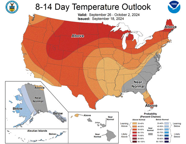
Figure 1. The Climate Prediction Center forecast favors a higher probability of above-normal temperatures into October nationwide.
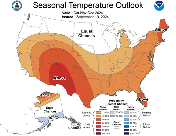
Figure 2. The Climate Prediction Center favors above-normal temperatures persisting into early winter for Kansas for the Oct-Nov-Dec average timeframe.
Could it possibly be that we won’t even experience frost on the pumpkin and not see a first freeze until November? Climatologically speaking, a first frost in November is uncommon to unprecedented, depending on location. Goodland and Manhattan have never recorded a first frost in November. It has only happened once in Dodge City’s 150-year period of record (Nov. 2, 1950). There are half a dozen instances of the first frost waiting until November at Topeka, the last coming in 1998. Further south, Wichita averages a first frost in November about once every eight years, the last coming in 2015. And then there’s the first freeze. The latest first freeze on record is after Halloween at many locations: November 13 in Manhattan, November 14 at Dodge City, and November 21 at Topeka and Wichita. On the other hand, Goodland has never had a first freeze in November; the latest on record is October 28. Could those records be threatened this year? It’s too soon to tell. A warm September doesn’t guarantee a warm October, although the forecasts suggest it’s more likely this year. But it takes just one cold air mass intrusion to end the growing season, and a single strong cold front will likely flip temperatures from above to below normal sometime before we reach the end of October. The later that occurs, the more likely sub-freezing weather will result. Until then, enjoy the warmth because, as the old saying goes, all good things must come to an end.
Matthew Sittel, Assistant State Climatologist
msittel@ksu.edu
Christopher “Chip” Redmond, Kansas Mesonet Manager
christopherredmond@ksu.edu