As the summer cropping season moves into full swing across Kansas, growers are making multiple early-season management decisions that depend on timely, effective field scouting. Early-season field scouting is vital for assessing soil moisture conditions, surface residue cover, wet or waterlogged areas, monitoring early weed pressure, and evaluating crop emergence and stand establishment.
For example, identifying waterlogged areas within the field during early-season scouting helps growers avoid soil compaction, improve machinery movement, detect drainage issues, and recognize zones with poor soil aeration that may negatively affect crop emergence and root development. Similarly, early-season assessments help growers make informed decisions regarding weed management strategies, and post-planting plant stand counts are especially important because they provide valuable insight into germination success and overall crop establishment. Normally, early-season scouting and plant counting are conducted manually by visiting fields, walking through different areas, and visually assessing conditions. While this approach can provide accurate observations, it is labor-intensive, time-consuming, and often difficult to scale across entire fields. As a result, growers may evaluate only a limited portion of the field and make broader assumptions about overall field conditions based on a relatively small number of observations.
With recent improvements in drone technology, it is now possible to cover the entire field across much larger areas with far less labor and in less time. The goal of this approach is not to replace manual field scouting, but to expand it, giving producers a more complete picture of their field.
Drone-based early-season scouting
Soil variability
A fixed-wing drone equipped with RGB and multispectral sensors was used to collect imagery from an approximately 150-acre field at the Flickner Innovation Farm in McPherson County on May 2, 2026. The RGB imagery provided a high-resolution, human-eye view of the field, while the multispectral imagery was used to generate a vegetation index map, such as the normalized difference vegetation index (NDVI).
When used together, RGB and NDVI imagery provided complementary information for early-season scouting and field assessment. The RGB imagery (Figure 1a) helped identify visible field features, including soil surface variability, crop residue distribution, irrigation traffic patterns, and low-lying or waterlogged areas. In contrast, the NDVI image (Figure 1b) highlighted spatial differences in early crop emergence, planting progress, and overall field variability that may not be readily apparent in standard RGB imagery or to the human eye.
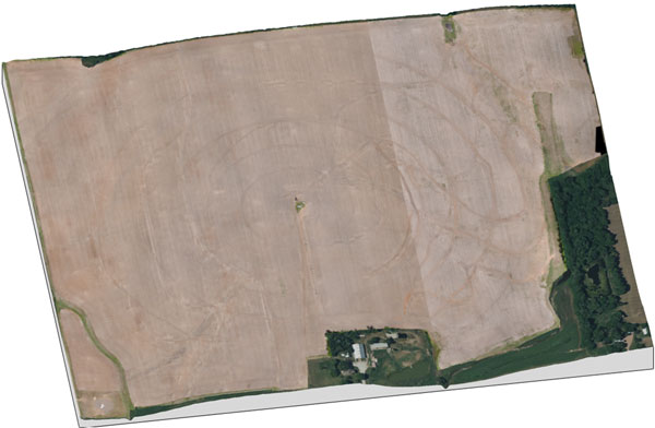
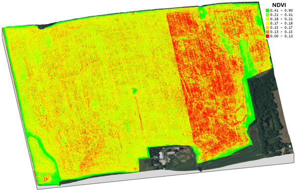
Figure 1. High-resolution drone imagery – RGB (a) and NDVI (b) collected on May 2, 2026, showing early-season field conditions, soil surface variability, residue patterns, and topographic variability areas across the field. Images by Deepak Joshi, K-State Extension.
Early Germination and Emergence Variability
Super-high-resolution RGB imagery (0.07 inches/pixel) was used to assist in stand count estimation in a corn field in Riley County (Figure 2). Early-season stand counts are important because it helps growers evaluate germination success, emergence uniformity, and overall crop establishment shortly after planting.
The image also illustrates spatial variability in emergence across planting rows. Some rows show more uniform (yellow dashed box in the image), consistent plant spacing, while others exhibit visible gaps where emergence may have been delayed or unsuccessful (blue dashed box in the image) (Figure 2). Such variability can result from differences in soil moisture, planting depth, residue distribution, seed-to-soil contact, compaction, or localized environmental conditions. Detecting these patterns early in the season enables growers to identify problematic areas that may require additional scouting or management decisions, including potential replant evaluation. Moreover, early-season NDVI maps also provide valuable insight into the overall spatial variability of crop emergence, early growth, and germination across the field, helping growers identify areas with uneven establishment or delayed development (Figure 1b).
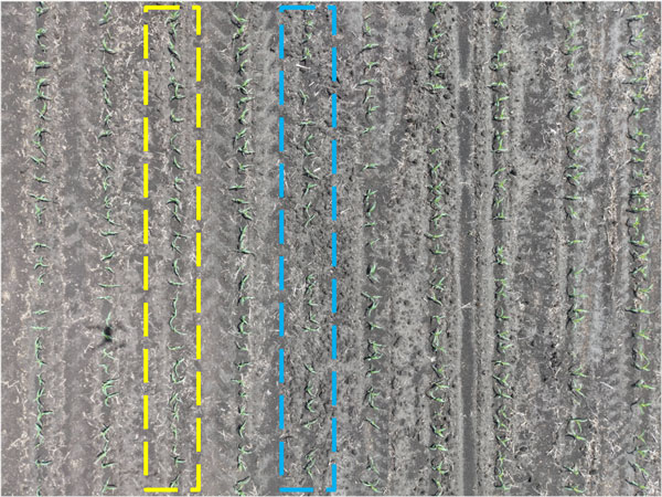
Figure 2. High-resolution RGB drone imagery demonstrating early-season plant stand and germination assessment. Corn rows inside the yellow dashed box have quite uniform germination with consistent plant spacing, while the yellow dashed box rows consist of some missing and gaps in germination. Image by Deepak Joshi, K-State Extension.
Conclusion
UAV-based early-season scouting offers a practical, scalable way to assess soil variability, plant stand count, and early germination. However, the effectiveness of drone-based scouting also depends on image resolution, which is influenced by factors such as flight altitude, sensor type, weather conditions, battery life, field size, and others. Additionally, growers and drone operators should always follow Federal Aviation Administration (FAA) regulations and safety guidelines when operating drones to scout the agricultural fields.
Kaden Spencer, Graduate Student in Precision Agriculture
Deepak Joshi, Precision Agriculture Extension Specialist
drjoshi@ksu.edu
Logan Simon, Southwest Area Agronomist
lsimon@ksu.edu
Tina Sullivan, Northeast Area Agronomist
tsullivan@ksu.edu